Fixing by radar ranges, and a running fix
Both GNSS fail: fix by radar ranges of charted marks on the ECDIS, then a running fix, and log it.
- Phase 3: Fixing the position
- 5 steps on the bridge
- 4 oral questions
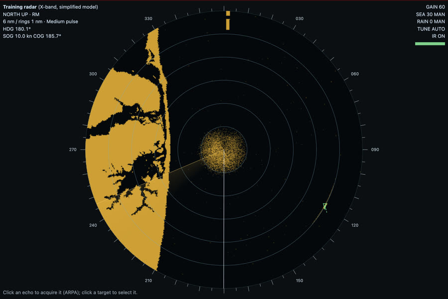
What you do on the bridge
- GNSS lost
- Two radar ranges
- Fix
- A running fix
- Log it
The oral questions, and what a good answer covers
The key points are in our own words. In the course, these questions come once you have done the job.
Why are radar ranges better than radar bearings for a fix?Often asked
A good answer covers:
- Bearings suffer from the horizontal beam width, which widens the echo, and from heading and gyro errors
- So ranges from two or three marks give the best radar fix; a bearing can be added as a check
- Use the VRM on the nearest edge of the echo, on a range scale that puts the mark well out from the centre
Show me on the bridgeFind buoys S and 4 on the radar. Which edge of each echo would you range on?
How do you choose marks for a radar fix, and what can go wrong?Often asked
A good answer covers:
- Charted, radar-conspicuous objects whose position is certain: a racon, a light structure, a steep headland, a small rock
- Avoid low, sloping coasts where the radar edge is not the charted coastline
- Buoys can be off station, so check them against other marks
- Two marks about 90 degrees apart give the best cut; three marks show up a mistake as a cocked hat
- Make sure you have identified the echo: compare the picture with the chart
What is a running fix, and what are its weaknesses?Often asked
A good answer covers:
- A position line taken earlier is run on along the course and distance made good to the time of a second line, and the fix is where they cross
- Useful when only one mark is in sight or on the radar
- Its accuracy depends on the course and speed used to run the first line on
- An unknown set and drift moves the fix, so it is less reliable than a fix from simultaneous lines
Both GNSS fail in a channel approach. What do you do?
A good answer covers:
- Acknowledge the alarm and confirm the ECDIS is in dead reckoning, using the gyro and the log
- Fix at once by radar ranges and visual bearings, and keep fixing at short intervals
- Use parallel indexing on the radar to keep the track
- Call the master, consider slowing down, and inform VTS if in an area that has one
- Log the failure, the time and each fix
How the lesson runs
The tutor's narration from the lesson, step by step. On the bridge, each control lights up as it is named.
Brief
We're inbound in the Ambrose approach at six knots, both radars running. In about a minute, both GNSS receivers will stop.
When they do, the ECDIS falls back to dead reckoning. We'll fix the ship ourselves, by radar ranges of the buoys around us.
GNSS lost
There's the alarm: no position from either receiver. Acknowledge it. The ECDIS now shows DR, worked from the gyro and the log, and DR drifts with every minute that passes.
Two radar ranges
Pick two charted buoys that paint well and lie well apart in bearing: buoy S to the west and buoy 4 to the north-west are good.
Put the VRM on the near edge of each echo, read the range, and enter it on the ECDIS as a range line from that buoy. Do them one straight after the other.
Fix
Select both range lines and press Fix. In DR the ECDIS takes the fix and restarts its dead reckoning from it. If you add a third range, a big cocked hat tells you one of them is wrong.
A running fix
Now suppose only one mark were in sight. Take a range of it, wait at least three minutes, then take another line, from the same mark or another.
Fix from both. The ECDIS runs the first line on along our track to the time of the second. That is a running fix. It is only as good as the course and speed used to run it on.
Log it
Write it up in the deck log: the time both GNSS failed, that the ECDIS is in DR, and the fixes by radar range.
The rules and guidance behind it
- MGN 379 (M+F) Amendment 1: use of electronic navigational aids
Do it, then explain it.
Read the answers here for free. With a pass you work this lesson on the bridge, then practise its questions and mark your answers.