ECDIS and electronic aids: oral questions and answers.
27 questions from 7 lessons, with what a good answer covers. Most-asked first within each lesson.
Reading the answers is free. "Show me on the bridge" opens that moment in the simulator, with a pass.
Echo sounder and speed log
Find the wrong draught in the echo sounder, set the datum and alarm, and use water and bottom track correctly.
How does an echo sounder work, and how do you set it up?Often asked
A good answer covers:
- It times a sound pulse from the transducer to the bottom and back, using an assumed speed of sound in sea water
- It measures below the transducer; below the keel and below the waterline come from the draught and transducer depth entered
- Set the draught, the datum you want, the range and the gain, and a shallow alarm
- Check the reading against the charted depth plus the tide
Show me on the bridgeThe echo sounder as the last officer left it. Is the depth below the keel right?
What errors and false echoes can an echo sounder give?Often asked
A good answer covers:
- A wrong draught or transducer depth entered gives a wrong depth below the keel
- Aeration under the hull, in heavy weather or going astern, can lose the bottom
- Mid-water layers, fish or plankton can give false shallow readings, especially with high gain
- Multiple echoes, and second-trace echoes from a deep bottom on a short range
- On a slope it shows the nearest bottom, not the depth straight down
What is the difference between water track and bottom track on a Doppler log, and which do you use for what?Often asked
A good answer covers:
- Water track measures speed through the water, from a layer just under the hull
- Bottom track measures speed over the ground, while the bottom is in range
- Water track for collision avoidance: the radar is then sea stabilised and target aspects are true
- Bottom track for berthing and anchoring, where speed over the ground matters, often with sideways speeds at bow and stern
What other kinds of speed log are there, and what are their limits?
A good answer covers:
- Electromagnetic log: speed through the water from the voltage the flow induces; needs calibrating
- Impeller or pitot logs on small craft: fouling and wear make them under-read
- Doppler log: can give speed over the ground in shallow water, and through the water anywhere
- GNSS gives speed over the ground only, and fails with the GNSS
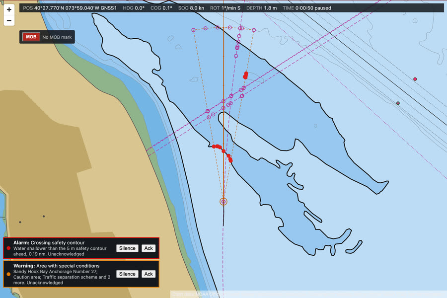
ECDIS: safety settings and alarms
Work out and set the safety depth and contour, the display and the look-ahead, and see the anti-grounding alarm work.
How do you choose the safety contour and safety depth, and what does the ECDIS do with each?Often asked
A good answer covers:
- Start from the draught, add the under keel clearance the company or master requires, and allow for squat and the tide relied on
- Safety depth: soundings at or shallower than it are shown bold, as a warning
- Safety contour: the line between safe and unsafe water; the anti-grounding alarm and the route check work from it
- If the chosen value is not in the chart data, the ECDIS uses the next deeper contour and says so
You take over the watch and look at the ECDIS. What's wrong with this picture?Often asked
A good answer covers:
- The default safety contour is in use: nobody set it for this ship
- Base display: soundings and many dangers are hidden
- A one minute look-ahead gives no time to act
- Audible alerts are off
Show me on the bridgeThe settings as the last user left them. What is wrong?
How do you set the look-ahead, and why does it matter?Often asked
A good answer covers:
- It is the area ahead the ECDIS searches for the safety contour, dangers and special areas
- Long enough to take action in time at the speed you are making, set by time or distance
- Wide enough to cover the yaw and the set, but not so wide it alarms all the time in a channel
- Too short or too narrow and the alarm comes too late; switched off it never comes at all
What are the dangers of over-reliance on the ECDIS?Often asked
A good answer covers:
- It is only as good as the chart data, the position input and the settings
- Cross-check the position by another means: radar, visual bearings, the echo sounder
- Watch for overscale, wrong datum, missing cells and the CATZOC of the data
- Keep a proper lookout and a radar watch: the screen is not the window
- Know the back-up arrangements and practise them
What are the Base, Standard and All display categories, and which do you use?
A good answer covers:
- Standard: what the ECDIS shows by default for route planning and monitoring, adding buoys, lights, traffic schemes and more
- All: everything, including spot soundings and cables
- Use Standard as the normal display, with soundings switched on near shallow water; remove clutter with care
- A customised display is flagged on screen
ECDIS: route planning and the route check
Check a route left unchecked, re-plan it along the channel, set XTD and turn radii, check again and monitor it.
What does the ECDIS route check look for, and what are its limits?Often asked
A good answer covers:
- Each leg with its cross-track corridor is checked against the safety contour, isolated dangers and the area categories you have chosen
- Results must be read one by one, and the route changed where it is unsafe, not just acknowledged
- It only knows the chart data and your settings: a wrong safety contour gives a wrong answer
- A visual check of every leg on a large scale is still needed
Show me on the bridgeA route left unchecked in route planning. Check it and read the results.
How do you choose the cross-track limits and turn radii for a route?Often asked
A good answer covers:
- XTD from the safe water each side of the track: narrow in a channel, wider in open water
- Wide enough for normal yaw and set, so the alarm means something
- Turn radius from the ship's turning ability at the planned speed and the room in the turn
- Wheel-over points follow from the radius; check them on the chart and with parallel index lines
- The route check sweeps the whole corridor, so a wide XTD can bring in dangers a narrow one would not
Once the route is being monitored, what do you watch for?
A good answer covers:
- Cross-track error and the off-track alarm; correct early for set
- Approach to waypoints, wheel-over and critical points
- The anti-grounding and area alarms from the look-ahead
- Cross-check the position by radar and visual means; do not trust GNSS alone
- Keep track control and heading mode clear in your mind, and know how to take hand steering
AIS voyage data on getting under way
Bring the AIS voyage data up to date before sailing: status, draught, destination, ETA in UTC and persons on board.
What information does AIS send, and which of it does the officer of the watch enter?Often asked
A good answer covers:
- Static data, set at installation: MMSI, name, call sign, IMO number, length, beam, type and antenna position
- Dynamic data from the sensors: position, course and speed over the ground, heading, rate of turn
- Voyage data, entered by hand: draught, destination, ETA, hazardous cargo and persons on board
- Check it at the start of every voyage, and whenever anything changes
What are the limitations of AIS for collision avoidance?Often asked
A good answer covers:
- Not every vessel carries it, and it can be switched off
- The data is only as good as what the other ship entered, or her sensors give
- Positions come from her own GNSS, which may be wrong; her heading and COG may differ
- Updates are not instant, so a turning ship may lag on the display
- It does not replace radar, plotting and a proper lookout, and the collision regulations still apply
When may AIS be switched off?
A good answer covers:
- The time and reason go in the log
- It goes back on as soon as the threat has passed
- In port, follow the port's rules on AIS
We're about to weigh anchor. What's wrong with our AIS?
A good answer covers:
- Status shows moored, and is not changed to under way using engine
- Draught 2 metres, the shipyard figure, not her present draught
- No destination
- No ETA
- Persons on board shown as none
Show me on the bridgeThe AIS unit on the after bulkhead, as the last officer left it.
ENC updates and permits
Read the ENC holdings, load the new permits, apply the updates and make a chart status report before sailing.
How do you know the ENCs on your ECDIS are up to date?Often asked
A good answer covers:
- Check each cell's edition and the last update applied against the latest available, from the weekly update and the chart agent's list
- Check permits are in date for every cell needed, for the whole voyage
- Make a chart status report and check it, and record updates in the chart log
- Check the updates were applied properly: review the changed features on the chart
- Check temporary and preliminary notices and navigational warnings are on the chart, as manual updates or notes if needed
Show me on the bridgeThe ECDIS Charts tab: one cell behind, one permit expired, one about to expire.
What is an ENC permit, and what happens when one expires?Often asked
A good answer covers:
- ENCs are encrypted; the permit is the key that lets this ECDIS decrypt and display a cell, for a set period
- Permits come from the chart agent and are loaded on the ECDIS, usually as a permit file
- An out-of-date cell does not meet the carriage requirement and should not be relied on
- Check expiry dates before sailing, cover the whole voyage, and renew in good time
You find a cell with an expired permit and an update waiting. What do you do, and in what order?
A good answer covers:
- Load the new permits first, or the update cannot be applied to that cell
- Then apply the updates, and check every cell has taken them
- Review the changes on the chart for the area of the passage
- Make and keep a chart status report, and tell the master if anything needed for the passage is missing
GNSS errors and spoofing
Spot a GNSS receiver walking away from the truth, cross-check, change the primary, and report it.
What errors affect a GNSS position, and how do you know how good it is?Often asked
A good answer covers:
- Satellite geometry: a high HDOP means a poorer fix
- Ionospheric and tropospheric delays, multipath near large structures, and receiver noise
- Jamming and spoofing, which can give no fix or a wrong one with a good status
- Datum: the position must be on the same datum as the chart, usually WGS 84
- Watch the status, number of satellites and HDOP, and always cross-check by other means
How might you detect that the GNSS is being spoofed, and what would you do?Often asked
A good answer covers:
- The two receivers disagree, or the ECDIS position no longer matches the radar picture or visual bearings
- The echo sounder disagrees with the charted depth, or speed and course over the ground look odd
- Change to the good receiver or to dead reckoning with radar and visual fixes
- Do not let the autopilot or track control follow a false position
Show me on the bridgeWatch the secondary difference in the Sensors tab as GNSS 1 starts to walk away.
What are differential GNSS and SBAS, and what do they give you?
A good answer covers:
- A reference station at a known position measures the errors and broadcasts corrections
- Differential GNSS sends them by radio beacon; SBAS sends them from geostationary satellites
- Better accuracy, and integrity warnings when a satellite is unhealthy
- Corrections only help while they are received: check the receiver shows a differential or SBAS fix, not a plain one
What is eLoran, and what errors does it suffer?
A good answer covers:
- A low frequency terrestrial radio navigation system, independent of satellites
- Ground wave propagation, so useful as a back-up if GNSS is jammed
- Errors from the signal travelling over land, which slows it, and from sky waves at night
- Corrections from reference stations (differential eLoran) improve it; coverage depends on the stations in service, and several national services have closed
AIS for situational awareness, and what it does not show
Set the AIS overlay and activation range, read a Class B target, find a boat with no AIS on the radar, and cross-check AIS with ARPA.
What are the limitations of AIS for collision avoidance?Often asked
A good answer covers:
- Not every vessel carries AIS, and it can be switched off: small craft, fishing boats and warships may not show
- The data are only as good as the other ship's sensors and what her crew entered: position from her GNSS, heading from her gyro, a wrong navigational status
- Class B transmits less often and at lower priority, so its picture lags more
- Reports can be lost in a busy area, and positions are not checked against radar
- So AIS is an aid to the look-out and to identification, never a substitute for radar and a proper visual look-out
Show me on the bridgeCompare the AIS targets with the radar echoes. Is there an echo with no AIS?
What is the difference between AIS Class A and Class B?Often asked
A good answer covers:
- Class A is carried by SOLAS ships: higher power, reports every 2 to 10 seconds under way depending on speed and turning, and every 3 minutes at anchor
- Class B is for small craft: lower power and a slower reporting rate, every 30 seconds above 2 knots and every 3 minutes below (Class B CS)
- Class B sends less voyage data: no navigational status, destination or draught
- Both show on the ECDIS and radar, often with a different symbol or label
What is the difference between a sleeping and an activated AIS target?
A good answer covers:
- A sleeping target shows only its position and heading: no vector and no CPA alarm
- An activated target shows its vector, its data on selection, and takes part in CPA and TCPA alarms
- Targets can be activated by hand, or automatically by range or CPA limits that the officer sets
- Leaving the activation range too short means a closing ship stays asleep until it is close
Should you use AIS to identify a ship and call her on VHF to agree how you will pass?
A good answer covers:
- AIS helps identify the ship, but VHF agreements are a known cause of collisions: the wrong ship may answer, or the agreement can break the rules
- Act in line with the COLREGs; do not rely on an agreement in place of them
- If you do call, identify her positively, and still check that the action taken is working
- AIS safety-related text messages are not a substitute for a proper call when urgent
See the lessons and a clip on the ECDIS and electronic aids page. Preparing for the OOW 3000 oral? See the syllabus, topic by topic.